
If Governor Baker’s Transportation’s Future committee report has it right, the City of Boston will, for the next 20-plus years, experience population growth more typical of cities in Arizona and Texas. And that our State’s mountain counties and Cape Cod will decline in population.
Nothing that the Committee report foresees has larger significance than that.
To opine first and then quote at length :
Boston is growing fast. From 2010 to 2040 the City is expected to increase population by 31.5 % !
Which means about 800,000 people in a City where barely 600,000 lived in 1990.
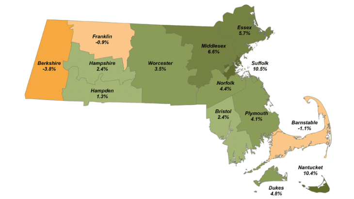
“Population growth in Massachusetts is highly concentrated in the eastern part of the state. While Greater Boston alone makes up 45 percent of the state’s population, it accounts for 67 percent of population growth since 2010.
…growth is even more concentrated in the urban core, close to
where the jobs are: Greater Boston region is one of a minority of metropolitan areas in the US where the primary city growth rate is higher than the suburban growth rate. Communities with high-frequency subway service accounted for 42 percent of Massachusetts’ net job growth in the last decade, up from only six percent in the previous decade for those same communities.
Future projections for the state exhibit this uneven growth trend: communities in Greater Boston and Central Massachusetts are expected to grow, while Berkshire and Franklin counties in Western Massachusetts and Barnstable County on the Cape are expected to contract over time.”
Politically, these population facts command large changes in representation. Today, Boston has 17 State Representatives and five State Senators. If the population predictions come to pass, by 2040 the City will have 22 State Representatives and six, maybe seven, state Senators. Meanwhile, the numbers for Berkshire, Franklin, and Barnstable counties will decrease accordingly. It’s likely, too, that representation for central Massachusetts will decline, while that for the Route 128 communities will increase.
This assures that the transportation priorities of Boston voters, and of those who live in its nearby suburbs, will dominate state planning, and that the transportation needs of people living outside metro Boston will be heard less and less. This imbalance is already happening, despite the best efforts of Governor Baker to bring new institutions and enterprise to the Connecticut valley and beyond.
To sum the situation up : for communities west of Worcester, connection to the “Hub” will be the be-all and maybe the end-all; while for the “Hub,” a major overhaul of every transportation infrastructure will be crucial.
Boston, with its enlarged political voice, will win most of the fights. What fights ? These :
( 1 ) vehicle traffic will have to be channeled. No longer will through traffic be able to monopolize major streets. In addition, through traffic will have to be directed away from narrower, and shorter, neighborhood streets. Both of these situations have already reached critical mass.
( 2 ) the central Artery, planned for 1970s traffic, has become almost unusable. Between 7 am and 10 am and again from about 3.30 pm to 7.15 pm, everything is slow-crawl or worse. Some through traffic, at lest, must be directed elsewhere. From Sullivan Circle all the way to Columbia Road, so many entry roads feed the Artery, or exit from it, and from opposite sides, that much traffic criss-crosses the wide roadway in order to exit, across entering traffic from the feed roads. The exit from Artery to the Ted Williams Tunnel narrows down to one lane, backing rush hour traffic for over an hour. This is what it’s like today. Imagine it in year 2040, in a city with one-third more people.
Suggestion ; a by-pass tunnel, built under Mystic River and Harbor, from Wellington Circle in Medford to University of Massachusetts campus in Columbia Point, accessible only to passenger vehicles. (with roof built low enough to assure it)
( 3 ) From Boston downtown to Pittsfield is about 140 miles. Only the first 25 miles or so lie in metro Boston, another 25 in greater Worcester. Beyond that lie communities losing population and influence. These are already served, somewhat, by the Turnpike in the south and Route 2 to the north. Traffic is not a problem, but road time is. I’m not a big fan of high-speed rail., but to offer people of our west a speedy connection to Boston, I don’t see a choice. Because the Connecticut valley sits perpendicular to the east to west flow that really matters, any high sped rail line will need two spurs, one to Springfield, the other to Greenfield, to feed the east-west rail running from Pittsfield to Worcester along current Route 9 and then onto the existing Worcester to Boston commuter rail. An important issue is : how frequent the train trips ? This will not be a heavy-usage line. I’d suggest that the east bound trains leave at 5 .30 am, 6.30 am, 7.,30 am,. 8.30 am, noon, and 3 pm, and that the west bounds leave at corresponding times.
( 4 ) the North Shore corridor. Vehicle traffic coming into Boston from the north has few options, thus the major one, Route 1 A, is as backed up as the central Artery when one needs it most. Route 93 isn’t any better. There are no other major access roads. What then to do ? Suggestions : ( a ) extend the Blue Line — finally !! — to Lynn, maybe t.o Salem ( b ) extend the Orange Line to Route 128 between Wakefield and Reading ( c ) build a service road alongside the Orange Line accessible only to passenger vehicles
( 5 ) Hyde Park and beyond. Traffic here hasn’t yet overloaded, but the day is coming. Suggestions : (a ) build a service road alongside the commuter rail Fairmount Line, accessible only to passenger vehicles ( b ) extend the Mattapan high-speed trolley line from Mattapan Square along Route 138 all the way to Stoughton ( c ) build the South Coast rail line
( 6 ) Cape Air’s Dan Wolf has a seaplane proposal for transport up to and across Boston harbor, including servicing Logan Airport. It should be looked at with favor,
( 7 ) Logan Airport. We’re very lucky to have our city’s major airport so close to Downtown. On the other hand, traffic to the airport impacts East Boston more and more, and rising seas threaten its very low-lying runways. It may be best to expand the Airport more toward Deer Island and perhaps even shift its footprint half a mile to the southeast, freeing up space for East Boston to develop normally and diversely and with less noise.
Overall : Governor Baker’s Future of Transportation report also emphasizes the need to decrease the carbon emissions put into the atmosphere by traffic jams and non-electric vehicles and trains. The report correctly prays that future public transit vehicles be electric, and it encourages electric vehicles generally. This is far less difficult a proposal than the basic infrastructure challenges, and it’s one proposal that the Commission Report can look forward to success at.
For further reading, it might be instructive to look at this, by Transportation for Massachusetts, a public interest advocacy group,which offers this proposal to the State’s recently released policy statement : https://d3n8a8pro7vhmx.cloudfront.net/t4ma/pages/314/attachments/original/1537900718/white_paper_final_9-21.pdf?1537900718
In my next installment I’ll look at some of the Baker Commission’s specific suggestions.
—- Mike Freedberg / Here and Sphere

